


Due to essential maintenance, the WEST footpath/cycleway is closed. The EAST Footpath/Cycleway remains open unless due to high winds or an incident.
Access RestrictionsBlog: Ground control
James Hepher - Rae Project Senior Digital Documentation Officer, Historic Environment ScotlandSurveying The Forth Bridge is an adventure and a massive challenge.
The structure is a red geometric delight and happily it has now received the international recognition it deserves, with inscription as Scotland’s 6th UNESCO World Heritage Site.
During the course of this survey our team have:

1. Invented new devices with help from our resident “Q”, Alan that allow us to 3D laser scan from difficult to reach parts of the bridge: narrow under track walkways and the track way itself.

2. Developed a rapid static method of laser scanning and GPS positioning our data from the tracks

3. Laser scanned from the rail tracks as the sun rises over the Forth at 4.30 am
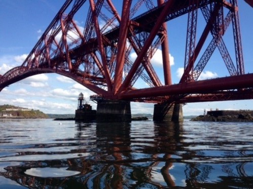
4. Laser scanned from shoreline and from Inchgarvie Island and Lighthouse both only accessible by boat.
All of the point cloud data in this project has been accurately captured with laser scanners chosen appropriate for the specific task:
- Faro Focus 3D: close range low noise data, under track walkways etc.
- Leica P40: longer range low noise data coverage scans that tie together larger parts of the structure
- Z+F 5010c: medium range low noise data detail scans of key aspects on the North and South sides of the Bridge
The scan data sets are brilliant in themselves as “localised chunks” depicting accurately every strut and rivet of parts of the structure …but working over a large area that takes in the Forth Bridge, Forth Road Bridge and Forth Crossing, requires a holistic overview or in surveying, a primary control network.
Our primary control network is a nine station traverse that loops around the rail and road bridges and takes in the towers and bridge supports that extend to the North and South from each bridge. We have used our freshly calibrated Leica MS50, a 1” “total station” with the capability for long range laser scanning to complete this traverse. Results of the traverse have been good.
Notable challenges have been negotiating the ~1 km stretches of water from the South shore to Inchgarvie Island and then on to the North Shore. Interesting things happen to laser beams over water as the water heats up with the temperature of the day. This is a well-known phenomenon when measuring over long distances with the laser beam diffracting. This has been counteracted by ensuring, where possible, measurements are taken at the coolest time of day and taking multiple “sets” of angular measurements to produce an accurate result.
In addition to the traverse we have recorded GPS data at the North and South Shoreline control points to georeference the traverse.
Completing the control loop from ground level has been the best way to ensure that The Forth Bridge, a structure that does move, is an accurately positioned dataset.
Our next challenge is to ensure that scans from the upper levels and caissons are tied in. With our strong primary framework this should not be a problem.

James Hepher