


Due to essential maintenance, the WEST footpath/cycleway is closed. The EAST Footpath/Cycleway remains open unless due to high winds or an incident.
Access RestrictionsBlog: Scanning the Forth Bridge
Mari McKee - Digital Documentation Intern, Historic Environment ScotlandHaving started my post at Historic Environment Scotland, assisting with the publication for the Forth Bridge World Heritage Nomination, I was thrilled when I found out I would have the opportunity to be a part of the CDDV digital survey of not only the Forth Bridge, but the Forth Road Bridge and the new Queensferry Crossing also.
The project was always set to be a challenge as the site spans such a great distance and the aim was to capture the bridges accurately and at a high resolution. Our approach required a flexible attitude as a lot of organisation depended on the weather, permits, health & safety and the hire of boats to access more remote areas such as the footings of the Road Bridge and Inchgarvie Island.
View from the North Stanchion of the Forth Road Bridge

Figure 1: View from the North Stanchion of the Forth Road Bridge
The project started at the Forth Bridge (rail); a huge and beautifully complex structure which we knew would be a challenge to survey in itself. It had been fairly daunting choosing a starting point, however a plan was made to focus our attention to one area at a time whilst making sure we tied our scans into the overall control network which was simultaneously being gathered for all three bridges
Seagull deterrents were added to our helmets!

Figure 2: Seagull deterrents were added to our helmets!
As there is a team of 11 working shifts at the bridge, it was very important to back up the data and keep track of our progress in order to check what areas have been completed. A spreadsheet was set up to ensure everything was backed-up and to record the details of each area, the file name, the no. of scans, file size, the surveyors on site etc. We used hyperlinks to make it very clear where to find the data or related files such as scanning site notes so that the person registering the data will be able to easily check that they have all the scans needed for each area and ensure that the entire team can track the project progress for its duration.I was fortunate to be on site a lot at the start of the project and working in public areas around the south shore of the rail and road bridge and taking boat journeys out to the footings of the Road Bridge and Inchgarvie Island. (Well - maybe not so lucky to work on Inchgarvie with hundreds of seagulls!) My favourite part however, was working on the Fife cantilever walkway which is just a couple of meters below track level and gives you an amazing close up of this spectacular structure.
Screenshot of the data management spreadsheet
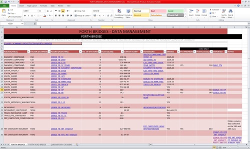
Figure 3: Screenshot of the data management spreadsheet

Mari McKee