


Due to essential maintenance, the WEST footpath/cycleway is closed. The EAST Footpath/Cycleway remains open unless due to high winds or an incident.
Open to all permitted traffic
Access RestrictionsBlog: Sizeable data management challenges
Adam Frost - Senior Digital Documentation Officer, Historic Environment ScotlandHaving walked, stooped and shuffled across a substantial distance on the Forth Bridge, I’ve certainly grown to appreciate the complexity and absolute scale of the structure whilst scanning it. Being part of a team with a rotating roster of laser scanning surveyors working on the bridge, my role has been divided between this fieldwork and in the office processing the 3D data. I’m managing the rapidly expanding database and connecting (‘registering’) the individual scans to form a cohesive 3D representation of the bridge, incorporating the primary control networks principally established via Total Station and GNSS.
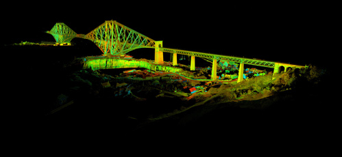
A preview of some of the data from the Fife bridge sections
The combined databases (excluding raw data and images) from the Forth Bridge and the Forth road bridge add up to over 1TB of spatial data so far, a statistic that will continue to grow until the very last scans are undertaken. This is the result of using 6 terrestrial laser scanners, each with its own role in providing a mixture of range and speed advantages. The reason these datasets are so huge is the combined factor of the density of the high resolution 3D data with the complexity of the structure. This can be visualised by subdividing the bridge into separate sections, where it’s easy to see how across the three main cantilevers – each section has taken hundreds of discrete scans under and on the track level alone, adding up to billions of points. Every new position reveals new areas of the bridge – beams, walkways, stanchions and tracks.
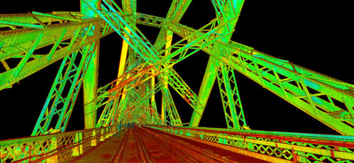
Track level scan data, showing the detailed data gathered overnight using the bogey-mounted Leica ScanStation P40
Track level scan data, showing the detailed data gathered overnight using the bogey-mounted Leica ScanStation P40
By mounting a scanner on a rail based mobile platform (a ‘bogey’), we’ve addressed a more rapid approach to recording the track level data whilst maintaining the high resolution and accuracy of terrestrial data. This is vital, as the track level scanning is undertaken overnight to avoid active trains on the lines, which would otherwise make access impossible. Nightshift on the bridge is a pretty unique experience, and the up-lit bridge with the panoramic views afforded by the early morning light over the forth is something special.

Adam Frost