


Due to essential maintenance, the WEST footpath/cycleway is closed. The EAST Footpath/Cycleway remains open unless due to high winds or an incident.
Open to all permitted traffic
Access Restrictions
Forth Bridges Viewpoint
Trail stopwhat3words///plenty.voltages.princely
GPS 55.987939, -3.403332
A Trio of Design
Three bridges from three centuries. Get the camera out for a selfie against the view; up towards Stirling, across to Fife or down river to the capital and the open sea.
The Forth Bridge
The Forth Bridge is a Scottish icon that is recognised the world over as the most famous of multiple cantilever designs, using a substructure of caissons.
A single cantilever is a structure that is only anchored at one of its ends. The unanchored end projects horizontally and helps to support the bridge. Cantilever structures rely on the balance of forces and this indicates the complexity of the Forth Bridge cantilevers.
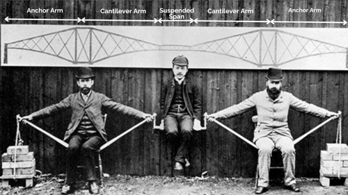
This photo shows how Benjamin Baker, the designer of the Forth Bridge, demonstrated a cantilever system. Pictured in the middle is Kaichi Watanabe, a Japanese engineer and student of Fowler and Baker who visited the UK to learn Western engineering techniques.
The Forth Road Bridge
The Forth Road Bridge is one of the world’s most significant long-span suspension bridges.
A long-span bridge is a structure that spans more than 120 metres.
A suspension bridge has two main parts: the superstructure and the substructure. The superstructure is the road, towers, and suspension cables. The substructure is the caissons (the foundations that support the towers) and the anchorages for the cables at the end of the bridge.
The suspension cables are strong yet flexible – sometimes you can feel the bridge moving slightly in the wind. It feels a little odd but it’s perfectly safe!
The Queensferry Crossing
The 1.7 miles (2.7km) structure is the longest 3-tower, cable-stayed bridge in the world. It is also by far the largest to feature cables which cross mid-span.
Cable-stayed bridges have one or more towers from which cables support the bridge deck. The cables run directly from the towers to the deck which creates a distinctive fan pattern. When lit up at night, this can look like angel’s wings and some local people call them the Angels of the Forth.
A public vote was held to confirm the name of the new crossing. The shortlisted names were Caledonia Bridge, Firth of Forth Crossing, Queensferry Crossing, Saltire Crossing and St Margaret's Crossing. Queensferry Crossing won, attracting over a third of all votes cast.

Essential Information
- There are public toilets here
- Parking available
- A cafe serving takeaway food is located here
Where Next on the Trail?
Depending on which route you are walking, the next stops are:
Forth Road Bridge South
South QueensferryThe Forth Road Bridge South is the iconic tower nearest to South Queensferry.
Location References
There are two walkways. Sometimes the East footpath is closed but you can still follow the route on the West footpath.
East Footpath South Tower
what3words///after.steadily.insurance
GPS 55.998774,-3.404056
West Footpath South Tower
what3words///freezers.assure.feathers
GPS 55.998774,-3.40449
Port Edgar
South QueensferryPort Edgar Marina is a lively destination for shopping, good food and brisk walks. You'll find toilets, retail opportunities and places to eat.
Location References
what3words///glorious.flirts.exploring
GPS 55.993357,-3.407335


See all Trail Stops

Forth Bridges Trail Maps
For North & South QueensferryYou can also use ///what3words to guide you to the trail signs. The ///what3words reference is given on each trail stop page.