


Due to essential maintenance, the WEST footpath/cycleway is closed. The EAST Footpath/Cycleway remains open unless due to high winds or an incident.
Access Restrictions
Intelligent Transport System (ITS)
Intelligent Transport System (ITS) technology deployed along the full Queensferry Crossing motorway corridor provides lane control, mandatory variable speed limit control and bus lane control.
This technology improves traffic flow, reduces congestion and improves road safety. ITS began operating on some of the roads covered by this guide in 2013, and in the first three years of operation accidents reduced substantially – by around two thirds.
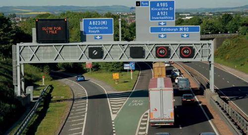
Overhead gantries spaced regularly along the route support the ITS equipment including motorway signals for lane and speed controls, variable message signs, CCTV cameras, journey time cameras and enforcement cameras including automatic number plate recognition.
- Entering the managed motorway
- Variable speed limits
- M90 HADECS camera system
- Bus lane/hard shoulder operation
- In case of breakdown or emergency
Entering the Managed Motorway

Fixed gateway signs indicate road users are entering or leaving managed motorway.
Variable Speed Limits
An Intelligent Transport System allows mandatory variable speed limits to be applied so that vehicle speeds can be managed during congestion and in response to incidents such as breakdowns.
Variable speed limits keep traffic moving by controlling the flow of vehicles when a road is congested. Using CCTV cameras and data from traffic flow detectors, Traffic Scotland’s National Control Centre can monitor traffic levels and lower speed limits to reduce traffic build-up.
A speed limit displayed inside a red circle is legally enforceable.
Failure to comply with a mandatory variable speed limit is a motoring offence. If you go over the speed limit you could receive a fine.
If no speed limits are displayed then the national speed limit applies. Where variable speed limits are displayed they remain in place until notified either by displaying the national speed limit sign or a different speed limit.
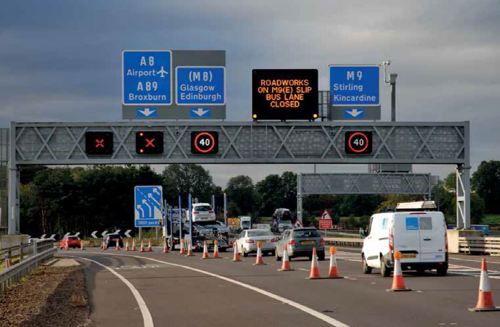
Mandatory variable speed limits are indicated by red rings on gantry signs while variable message signs can advise drivers of traffic conditions.
Blank signal
Normal motorway rules and speed limits apply.
Speed limit signal
The speed limit displayed is mandatory, is the maximum permitted and will vary to suit traffic conditions.
Red cross
If above a traffic lande, you are not permitted to travel further in that lane. If above a bus lane/hard shoulder, you may still use this as a hard shoulder in an emergency.
NOTE:
Other standard motorway signals may also be displayed. For further information, please refer to the Highway Code - an online version is available at www.direct.gov.uk
M90 HADECS Camera System
To keep traffic moving on the M90 over the Forth, an improved level of driver behaviour amongst road users is required.
To encourage compliance with the variable speed limit a camera enforcement system called HADECS (Highway Agency Digital Enforcement and Compliance System) is now operational.
A six-camera spot speed HADECS system is deployed on a 22km of the road network between the M90 at Halbeath and the M9 north of Newbridge.
Over this stretch of the road network there are over 200,000 vehicle movements every week. Over 30,000 vehicles are speeding on some sections of the route with over 4,000 vehicles speeding excessively. This has been causing stop start conditions, congestion and less reliable journey times, with journeys taking on average up to 5 minutes longer at peak times.
The HADECS camera system aims to encourage improved driver behaviour and enhance the levels of compliance with the variable speed limit. This is anticipated to lead to smoother traffic flows during busy periods and more reliable journey times.
The HADECS camera system progressed to live operation on Monday 23 May 2022.
For more information on driver behaviour on the M90 across the Queensferry Crossing, and the HADECS camera system, please visit:
Bus lane / hard shoulder operation
In various locations the hard shoulders have been configured to operate as a bus lane – see North road network and South road network. These locations are indicated by traffic signs.
Max bus lane speed signThe use of these bus lanes is legally restricted to buses and coaches that can carry 24 seated passengers or more. Any buses that do not meet this requirement are prohibited from using these bus lanes.

Intermittent green road surfacing and ‘Bus Lane’ road markings within the hard shoulder, at the start and end of the bus lane and repeated along its length, reinforce the presence of the bus lane.
Apart from the hard shoulders on the Queensferry Crossing, these bus lanes/hard shoulders operate on a 24-hour, 7 days a week basis. The Queensferry Crossing hard shoulders (northbound and southbound) may be used by buses and coaches when the Forth Road Bridge is closed (e.g. due to high winds) and when appropriate signs are displayed.
Motorway users should take care at slip roads as buses may carry straight on and re-enter the bus lane through the green marked section (see above photo). Motorway users must not follow buses through this restricted section.
Motorway drivers should be aware that buses are likely to use normal traffic lanes during non-congested periods as they can travel at higher speeds than the advisory 40mph maximum limit applicable to the bus lanes.
In normal operation, the bus lane is open and is indicated by a blank signal. Note the presence of an emergency refuge area.
In emergency situations, the motorway signal over the bus lane is used to advise bus drivers that the bus lane is closed – a red ‘X’ signal is displayed over the bus lane and the variable message sign reinforces this.
In case of breakdown or emergency
The bus lane is always accessible as a hard shoulder to any vehicle involved in a breakdown or emergency. When this happens buses are diverted to the normal traffic lanes.
In an emergency, one of the emergency refuge areas next to the bus lane/hard shoulder should be used. These emergency refuge areas have emergency roadside telephones with a direct connection to the Traffic Scotland Control Centre whose trained operators will advise and support you. The telephones are generally positioned behind roadside barriers and at a height suitable for road users with disabilities.
If you can’t reach an emergency refuge area in your vehicle, the hard shoulder should be used. Should you require a telephone, follow the directions on the roadside marker posts.
If you use your mobile to report an emergency, dial 112 or 999 to contact the emergency services. Always follow the Highway Code directions for breakdowns and incidents, including additional rules for the motorway (sections 274 to 287). An online version of the Highway Code is available at www.direct.gov.uk
